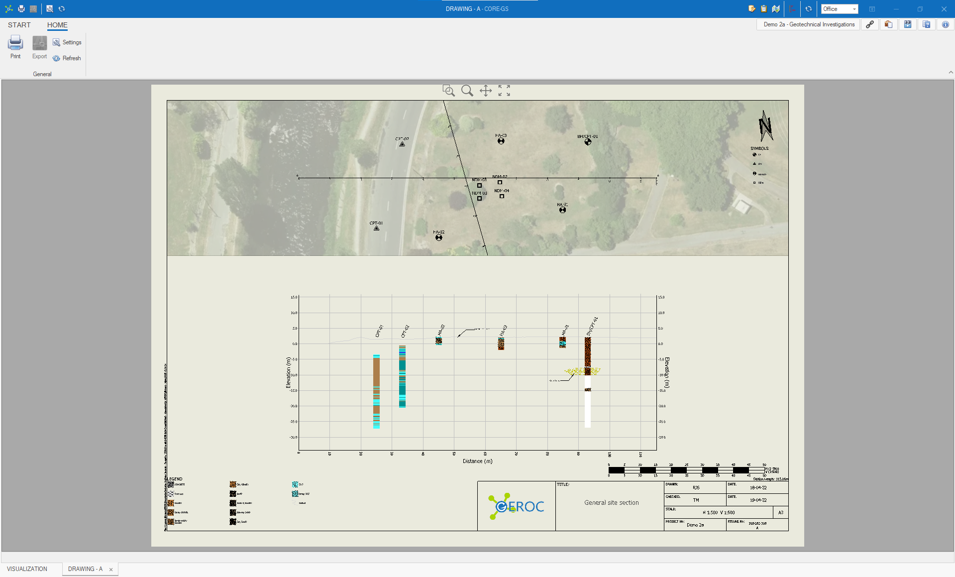
We've completely rebuilt the Visualization module in this release to greatly simplifies the process of generating models, plans and sections and taken the lead to provide simplified plans & sections in CORE-GS Standard!
Changes
- Enhanced Visualization module (previously Model & Sections):
- Added a pseudo 2D Plan environment
- Added the ability to create a ground surface directly from file (*.las, *.asc, *.dwg)
- Added the ability to create geo-referenced images
- Enhanced image draping
- Enhanced annotations (Text, Text with Leader, Points, Lines & Areas (with CAD hatching))
- Enhanced editing tools
- Enhanced layer controls
- Enhanced material assignment tools
- Enhanced surface tools
- Added LAS import
- Added 3D PDF and HTML (WebGL) export
- Added support for drawing template to be stored in the database
- Enhanced drawing support with layouts exported to CAD
- Added Azure Active Directory (AD) supported allowing secure connection to Azure Database
- Added a navigator map capture tool to simplify image sizing
- Added support for reports to be automatically generated with AGS exports
- Added support for extraction of parts from ranges in the Description Builder
- Enhanced scalable vector graphic (SVG) support
- Enhanced Workflows now includes SQL view source tables
- Enabled stored procedures to be run on import / export mappings with any license types
- Enhanced the merging of vertical text and navigation in reports
- Enhanced Navigator, with north arrow higher contrast selection color
- Enhanced hidden lookup item visibility (appended with (*))
- Fixed read / write issues of application data by moving from ProgramData to Public Documents
To make the most of these enhancements, contact us to discuss database upgrades.
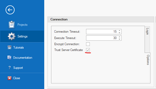
IMPORTANT NOTE:
If you use SQL Authentication to connect to your database, you will likely need to select the Trust Server Certificate option:
- Added Layer Manager for configuring map control base layers
- Added Workflow Highlight option to highlight cells that are used in a report
- Updated report engine with fixes, improvements and new features (i.e. split reports)
- Updated coordinate conversion and KML / KMZ libraries
- Added option to generate maps from the map control, with these saved into the file set data
- Added the option to select a report when creating new point features via the map control
- Added an option to show the report preview in a pock panel alongside data
- Added the ability to show full size images in a viewer
- Added the ability to add tables / columns and edit data types to existing synchronization scopes
- Added the ability to run multiple scopes using a synchronization playlist
- Added the ability to run synchronization from the Start screen
- Added a Record Conflict Resolver to the synchronization system allowing the user to decide which record remains
- Improved the pairing of databases used in the synchronization so this is only done once
- Improved hiding of unpinned panels when focussed by clicking on the header
- Improved the coordinate conversion system to process coordinate data that is pasted into the grid
- Improved the storage of report parameters in the database
- Fixed an issue stopping codes from being typed in the Description Builder
- Fixed an issue causing CAD export to fail when invalid layer names existed
- Added map control to record navigator / filter control with tile image (i.e. Bing Map & Open Street Map) and WMS support
- Added position indication using Windows Location Service
- Added geographic data types (i.e. points, polylines & polygons)
- Added in-place lookup editor
- Added project definable World, National & Local coordinate systems with active coordinate conversion between map and grid
- Added XML format to import / export system to allow transfer of XML data and large binary files (i.e. images)
- Improved camera support for dual camera devices
- Improved Record Commit to automatically saves data immediately after leaving a row
- Improved Auto Fill tool now supports dual depth (Top & Base) tables. i.e. Core
- Improved load speeds and other optimizations
- Improved project setup and edit from the Startup screen.
- Added Free-text lookup option allowing lookup lists to be suggestions.
- Added Conflict Resolver, that detects and fixes import issues, into the Standard version.
- Added Clarinspect API support (BETA) to avoid most of the manual steps currently required to import data.
- Added FILESTREAM support for storing and retrieving files in a database.
- Added Automation Add-in for the automated export of data and reports based on defined business rules.
- Improved Description Builder compatibility with AS1726:2017 and added user definable classifications and presets.
- Improved AGS export form allowing data from the Project table to populate controls on the Transaction page.
- Improved AGS export allowing values from the Transaction page to be used in any export group.
- Improved AGS export to automatically generate FILESET references when FILESTREAM is enabled.
- Improved Bulk Import to allow AGS, CSV and Excel file types.
- Improved CPT filters to allow users to define the row count, and added option to import mappings allowing filters and parameters to be custom defined.
- Improved Sync Add-in to work with individual projects or divisions, allowing smaller device databases and faster setup.
- Resolved issue with notifications following Windows 10 Creators edition release.
- Faster reload speed when changing projects.
- Improved transaction commit and data recovery system.
- Combined reports now runs on a separate thread showing progress.
- Changed report designer to work in MDI mode, allowing multiple reports to be opened for editing at the same time while continuing to use parts of the software and reload the designer with new filters.
- Changed 'OK' messages to show notifications instead.
- Changed to new license system.
- Added check if someone else has created a project.
- Added option to filter lookups at database level.
- Added support for one-to-one table relationships.
- Added row level commit option (BETA).
- Added option to export Views to Excel files.
- Improved messaging of information from Access database files.
- Added controls to Soil and Rock description builder forms to support AS1726:2017 and AGS3.1 RTA.
- Added 'Continued' method to join two descriptions without forming a new paragraph.
- Improved description builder extraction method (database assembly).
- Improved import support from Clarinspect to description builder.
17.2
- Faster Data module loading.
- Faster commands and response times.
- Faster Copy Down and Copy Point functions.
- Added ability to restart local SQL Server instance.
- Added the ability to capture photos from device cameras with overlay buttons for common tasks.
- Added file naming convention for saving data files and PDF's.
- Added load and save grid layouts from the CPT add-in.
- Added check to show or hide the Sync button based on the server location.
- Added a Division Selector if no division chosen.
- Improved AGS3.1 read / write.
- Windows 10 Compatible
- Revised Startup screen, with projects / modules easily accessible and quick access to project folders / permissions.
- All modules open in the same window for simpler navigation.
- Tables and columns can be customized for each division.
- Report functionality is more powerful, flexible and organised, with reports linked to tables to simplify complex reporting requirements.
- Import and export now supports data from virtually any table in the database.
- Synchronization functionality has been added, allowing fast and simple transfer of data and templates between a central database and field devices.
- Conflict resolution has been added to the import system to assist where data conflicting with database lookup codes is encountered.
- Simpler licensing has been added to minimize customer disruption while providing more options (i.e. floating license check-out and short-term licenses).
- Optimized for remote connections
- Faster loading of modules, with auto reload when changing projects
- Faster report generation
- Faster file read / write and data mapping system
- Inbuilt CSV and Excel read / write functionality
- Extended description builder functionality
- Improved model and section capabilities
- Improved CPT system allowing more flexible data import
- Improved Manager for permissions and users
- Integrated error reporting system
- Single installer for both 32 & 64 bit machines
- Updated documentation
NOTE: Upgrade to this version is not automated, as changes are required to migrate the database from the v1 to v2 structure.
Data module
- Added full support for SQL Views, including multiple table view editing
- Added new combined report generation mode allowing report merging
- Added option to copy only the data from Point table when copying a PointID
- Added a multi-line mode to the Workflow bar, so links are never hidden
- Improved Project Settings interface, now integrated into main interface
- Improved Description Builder interface, with setup controls in the Project Settings
- Improved Copy / Paste functionality, now supports internal row(s) copy / paste
- Improved Tablet mode now shows the on-screen keyboard
- Fixed message and prompt issue when user canceled an import / export
Report module
- Added check that automatically sets the Master Component on log pages
- Added direct connection to Point table from all child tables to simplify report setup
- Improved the dictionary to show aliases and data units, as shown in the main interface
- Improved floating bar positioning
- Fixed issue with dual text component size when broken across pages with text drawing set to Both
- Fixed angle property and control settings on vertical scale component
Model module
- Added auto-generate surface option that creates surfaces based on material assignments
- Added gridding system that provides ability to bound a surface by other surfaces
- Added option to show / hide panels
- Improved line drawing tools for model and section line creation
- Improved textural mapping allowing accurate image draping on irregular surfaces
CPT module
- Added option to reprocess qc & timestamp spike filters
15.1
General
- Rename Core-GS Log to Core-GS Standard, to indicate the inclusion of simple 3D model views
- Added improved user settings system, with network version checking system (i.e. central file that can update all computers with changes to connections and license paths)
Data module
- Added support for SQL Views - single table (editable) and multiple tables (read only)
- Added automatic selection of newly created project
- Added prompt for report template in Point table when new Point is created
- Added automatic setting of Hole Depth to '0' when new Point is created
- Added option to copy data from the Point table only when copying a Point (i.e. header only)
- Added a improved Description Builder that is more powerful with provision for multiple material descriptions (i.e. interbedded layers and transition from soil to rock)
- Added drag / drop for images being saved in database
- Added option to disable web updates, for software distribution via corporate systems
- Added saving import / export logs to both the source folder and optionally a central URL
- Improved caching of report templates to increase speed and reduce data transmission
- Fixed issues with continuous range on level 3+ tables where selection was not held
- Fixed delete Workflow messaging issue
Report module
- Improved scale object so label is drawn at the tick depth
- Added option to show scale as elevation
CPT Module
- Added import of seismic data for Gorilla (GRU) file format
- Added option to adjust the start depth of CPT's in the CPT module
- Added option to export all CPT's to the custom Excel format
- Moved import messages to panel in CPT module
- Fixed text merging issue
Model module
- Redesigned ribbon interface
- Converted to XML based file system
- Improved transparency support (included textured surfaces)
- Added HD graphics support
- Added font and picture support for CAD export
- Added transparency control to database layers
- Added option to store the entire model in file (*.mdlx) - does not require database when opening
- Added open from backup file option (*.mdlz)
- Added CAD import / export on separate thread
- Added navigation cube
- Project Settings - setup and share default locations for project files and folders. Quickly search for folders and file based on name, extension and other attributes. Open files and folders, and print directory lists faster than ever. (All versions)
- Tablet data import - import data from our upcoming tablet application (All versions)
- Horizontal position on report components - i.e. floating bar plot (All versions)
- Logarithmic widths on report components (including scale component) (All versions)
- Description Builder - define custom templates and lookup items (All versions)
- Optional US Imperial units on columns (All versions)
- New 'Pin-to-Surface' option in models to automatically assign elevations based on surface (Professional only)
- Faster Delanauy surfaces generation in models (< 5 seconds for 1,000,000 points) (Professional only)
- Surface concave hull (alpha shapes) process - constrains surface generation to data (Professional only)
- KML/KMZ data import with re-projection in models - import points, lines and polygon areas (Professional only)
- Update individual database layers - speeds up work on larger models (Professional only)
- Search tool in models to quickly locate investigations and layers (Professional only)
- KMZ support for import and export of data, including custom icons to represent investigation types (All versions)
- Coordinate conversion for most common global, national and regional systems (All versions)
- AGS 3.1 read / write functionality (All versions)
- Scripts are located on a dock panel for easy access (Professional only)
- Integrated CPT Module (Professional only)
- Windows 8 Compatible (All versions)
- Tablet Mode - a new mode has been added to optimize use on Windows 8 tablet devices (All versions)
- Rapid Reporting - the reporting system has been optimized to reduce enable report generation in less than 1-second (All versions)
- Data Permissions - a new permissions system has been added that enables controlling data access (Professional only)
- Linked Point's - plot data from multiple Point on the same log (All versions)
- 64-bit version - generate 3D models with huge data sets (i.e. 400+ CPT's) (Professional only)
- Kriging Function - use Kriging to interpolate between sparse data points (Professional only)
- Bulk gINT Import - import multiple gINT project databases, with automatic project creation (ADT Module - All versions)
- GeoLogismiki CLiq Import - import CPT liquefaction results in seconds for 3D visualization (ADT Module - All versions)
- KML Import - import 1000's of investigation locations from a Google Earth KML file in seconds (ADT Module - All versions)
- Bulk Export and Report Generation - export data from any project to all standard formats and generate bulk Log reports in a single step (ADT Module - All versions)
- In-built coordinate conversions (NZTM only) (All versions)
- New way to working with all laboratory data in a single grid (like Excel) (All versions)
- Extended import / export (Google Earth, Excel 2007 (*.xlsx), Access 2007 (*.accdb) , AGS4, CSV) (All versions)